What did Boundary Line stone plaque do at York Way?
The Story
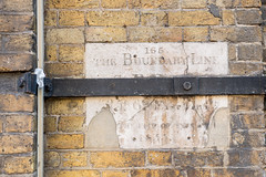
# 165 York Way: Where Victorian Boundaries Were Fixed in Stone Standing at 165 York Way in 1853, a surveyor's crew embedded this modest stone marker into the very fabric of London's expansion, capturing a moment when the city's administrative boundaries needed precise documentation for posterity. The inscription's cryptic measurements—35 feet 6 inches eastwards—record not just a line on a map, but a physical demarcation that settled property disputes and clarified parish jurisdiction during a period when London was rapidly consuming the surrounding villages and farmland. What makes this spot particularly significant is that it represents the practical, unglamorous work of Victorian city planning: the stone itself became the official arbiter of who paid taxes to whom, whose sewers belonged where, and whose parish church had spiritual authority over which streets. This modest marker at York Way thus serves as a quiet monument to the bureaucratic precision that made modern London possible, a reminder that behind every Victorian street and building stood careful men with theodolites and chains, literally marking out the future.
Location
York Way
Discover more stories across London